By Chris Connor
Co-Founder / CEO
Polaris Aero
“Spatial D!”
“Holy $#@%!”, I thought. Did I hear that correctly?
At this point in my Air Force career, I had been a pilot for about seven years. This was the first time I had heard the “spatial D” callout. “Spatial D” stands for “spatial disorientation”. It is a condition where a pilot’s internal gyros do not match the aircraft’s instrument readings. It results from a conflict between what a pilot sees on the instrument panel and what a pilot expects to see. According to the FAA, 5-10% of all general aviation accidents can be attributed to this “sensory mismatch”, 90% of which are fatal.
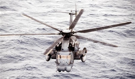
This night had all the warning signs for a potential “spatial D” situation – night, overwater, overcast cloud deck, and low illumination for NVGs (night vision goggles) – but I did not think it could happen to us. After all, we were flying one of the most advanced helicopters in the world – the MH-53M. This aircraft had advanced avionics and sensors. It was flown by a crew of six. We were well trained and highly motivated.
Before the flight, we did a risk assessment. Our risk assessment was a subjective hazard scoring system; we assigned numerical values to various hazards related to the flight. If the total score exceeded a certain value, we would need to get higher-level approval. For this flight, no such approval was required. The “risk assessment” had no impact on our mission planning, because the numbers did not provide meaningful information.
Our mission was a common one: drop off a special forces team at night. On the overwater leg of the flight, my co-pilot was at the controls. I was the non-flying pilot. As we were approaching our target, I briefly looked down to check the mission computer. As soon as I did, I heard my co-pilot call out “spatial D”.
At an altitude of fifty feet above the water, there was little time to react.
I immediately cross-checked both the pilot and co-pilot attitude instruments and saw they were both indicating a 30-degree angle of bank. I also briefly looked at the radar altimeter, which indicated we were descending through 25 feet above the water. (For reference, the rotor diameter of the helicopter was 72 feet.)
I grabbed the flight controls, immediately leveled the aircraft, then began a climb away from the water.
Whew, tragedy averted!
We continued with our mission and landed uneventfully. Afterwards, we debriefed the flight and learned our lesson.
The problem? The lessons we learned never left the briefing room.
Fast forward a few years. A Louisiana National Guard helicopter (UH-60M) was flying a similar training mission in the same location in northwest Florida. They encountered similar conditions to those we faced several years prior, but the result was quite different: both pilots got spatially disoriented and crashed in the Gulf. Eleven service members were killed.
What was the difference between my near accident and this accident? Luck!
My near-fatal flight had a profound impact on my safety outlook. Before, I viewed risk assessments as a waste of time. They were simply box-checking exercises that had to be completed before a flight. After, I realized their importance: the value of risk assessments is not the subjective numbers they generate; it is the sharing of knowledge they facilitate.
To make risk assessments meaningful, another retired Air Force pilot – Trent Fox – and I decided to start Polaris Aero.
Our first application: FlightRisk.
Our mission: to help people learn valuable lessons before an accident occurs.
Our method: to utilize technology to provide objective information.
By providing objective information about hazards and recommending risk mitigation actions, FlightRisk helps prepare pilots for the dangers they could face. This is the simple, meaningful, and seamless tool I wish I had when I was an Air Force pilot.
The right tool is much more effective than luck.
FlightRisk is an application on the VOCUS Safety Intelligence Platform.